Let me start this with a quotation:
“Every mountaintop is within reach if you just keep climbing.” Barry Finlay
And so we did. End of story. Char!
I just hope writing blog is this easy but it’s not. Like posting picture in Facebook and IG with CTRL+CV quotes courtesy of Google. Naku naku, guilty beyond reasonable doubt powhz xhie acqoe. Minsan kahit wala naman talaga kinalaman yung quotes dun sa picture. Laban! #ForFBStatus #ForTheGram #ForTheFame
Pero baka kung sa’n pa tayo mapunta, let me share to you Kagala a story. A story about our successful exploration of the untamed summit of Mount Mingan in Dingalan, Aurora. The most insane thing I did so far in my mountaineering career. But, who’s not excited about the idea of being the first group to summit anyway?
https://cdn.ampproject.org/v0/amp-auto-ads-0.1.js
And who’s to blame? Aside from me, the special long holidays brought by ASEAN Summit are responsible for this mixture of hardship and glory. Long holidays ba naman? Edi lumikot ang diwa ni Dudung at ayun na nga. Kung nagpirme ako sa apartment ko, di sana ako napariwara sa kabundukan ng Aurora. Disin sana meron pa akong dangal. Charing!
T h e P l a n
The Sierra Madre Range is the longest mountain range in the Philippines stretching from Cagayan Province (North Luzon) towards Quezon Province (South Luzon) and home of the most diverse ecosystem in the country. Along with its still unexplored peaks and ridges, it is by far, the largest contiguous and relatively intact representation of tropical forest habitats and largest national park in Luzon. And one of those yet unexplored summit in this mountain range is Mount Mingan, one of its candidate highest peak. Dzaah, feeling Kuya Kim kana niyan orb? Geh.
I am aware that there have been numerous exploratory attempts made to trail blaze the summit but were unsuccessful, mostly because of lack of time and due to unfavorable weather condition. I coordinated directly to the LGU of Dingalan thru Sir Albert, the Executive Assistant to the Mayor, for the permits needed for this climb and he advised me to just accomplish a Letter of Intent to climb including the names and information of the participants and sent it thru e-mail. He said that upon arrival at the Barangay Davil-Davilan we need to register and secure a waiver.
I find it not hard to look for a guide, since those who made several explorations in this mountain are my Facebook friends and were very kind enough to give me the contact details of Kuya Junior and Kuya Carding, the guide according to them who are familiar with the trail of Mt. Mingan. I coordinated with Kuya Junior thru phone call and have got valuable information of the necessary preparations and expectations during the climb whom I shared with to the rest of the climb party.
T h e C a s t
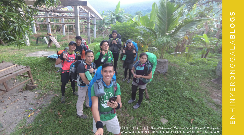
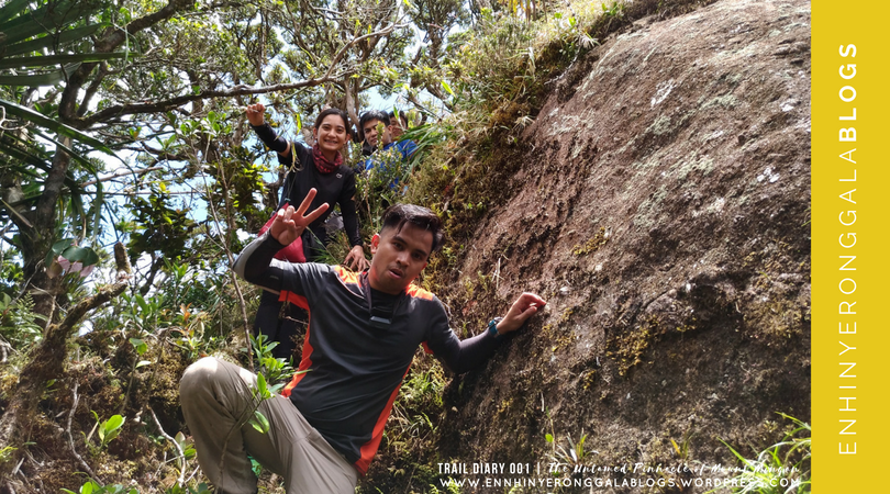
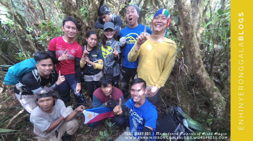
 Ang Itinakda. From left: Rodel, Eds, Rullet, Kuya Junior, Brgy Captain, Macky, Ram, JC and Yours truly
I organized a small climb party (sana lahat ng party masaya at chill…sana ALL!) whom I share with the expenses of this whole exploratory attempt. The climb party of nine was composed of three (3) good friends from Tipidkada (Macky, Rullet and Eds), three (3) recruits from an open invitation in Climber group (JC, Rodel and Ram) and two (2) mountain guides Kuya Junior and his son Byluck (Bilak). And of course, myself as punong abala at ang pasimuno ng kahibangang ito. Diko alam kong napatawad na nila ako sa pandadamay ko sa kanila HAHA.
Comes the most anticipated day, we huddled at Five Star Cubao Bus Terminal and took the bus going to Cabanatuan. We left Cubao around 11:00pm and we arrived Cabanatuan before 02:00am. We then transferred to a passenger van going to Dingalan. Since we are already seven with huge backpacks, atleast three (3) persons were needed to fill the sitting capacity of the van. We left Cabanatuan around 3am and arrived at Brgy Davil-Davilan around 4am. Early morning, we were fetched by Kuya Junior and transported us in his humble abode, which also served as the jump-off point of ‘Davil-Davilan Trail’ of Mount Mingan. There’s also another trail in Gabaldon, the nearby town of Dingalan.
We were surprised that Kuya Junior and his family prepared breakfast for us. We feasted over sausage, scrambled egg, hot noodles and of course steamed rice for carbo loading. Also, a fresh picked papaya as pang-himagas . Truly, one of the last happy hours of our hungry stomach before the dreaded exploration.
The Brgy. Captain logged our names and handed out waiver for signature. He also initiated a short safety briefing should emergency situation arise in our four (4) day journey. We paid a minimal amount of P50 as registration fee.
 Kapehan ni Kuya Junior. The team having a sumptuous feast at ang huling maliligayang oras. Selfie muna bago mawasak.
T h e C l i m b
DAY 01 | 28 April 2017. The Beginning
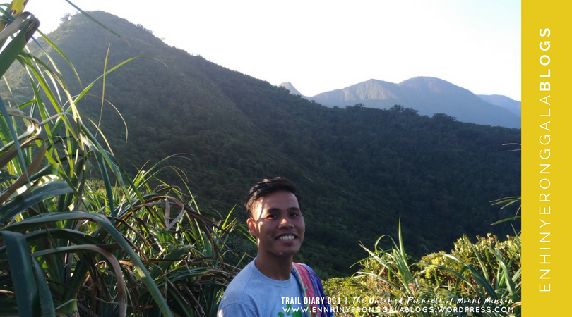
Past minutes before 7:00 in the morning, we embarked in a journey of the unknown. Armed with high hopes and aspiration to be the first group to stand atop the pinnacle of the untamed Mount Mingan, everyone were in high spirits.
 Selfie muna. Bago mawasak. Bago mabasag ang tuhod.
 Start trek. JC, Ram, Macky with our guide, Kuya Junior and one of his eldest son on the moves.
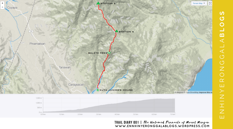
The jump-off point sits at an elevation of 80+masl, we shall cover around 1300+meters of elevation gain in order reach Station 6(~1450+masl). We passed through flat grassland on the first few minutes of the trail and crossed Lipos river, the source of potable water for the residents of Barangay Davil-Davilan.
 Lipos River. Ram holding her Nalgene bottle as she crosses the river.
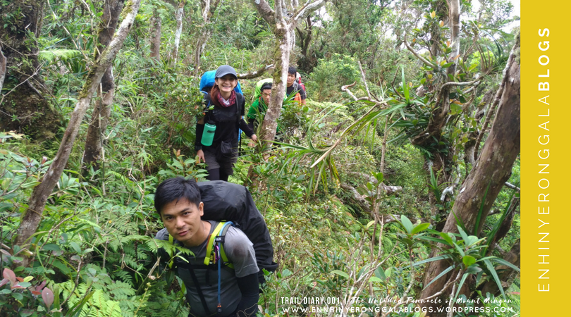
After 20 minutes on flat grasslands, we reached Station 1 with mark almost unrecognizable due to overgrown vegetation. From Station 1, the trail changes from grassland to rainforest with grueling medium to steep inclines – almost similar to the inclines of Mt. Mariveles from Papaya River towards Tarak Ridge. We reached Station 2 after 40 minutes and regrouped.
 Cardiac trail. JC, Rodel and the team managing a 40-minute straightforward, steep and heart pumping inclines.
Past Station 2, we reached the Balete tree landmark after 30 minutes. In the Philippines, the stories being connected with the tree are mostly a little horrifying. The likes of dwarves, ‘Kapre’ and ‘Tikbalang’ are often described in folklore as the creatures that thrives on this enchanted trees. Though I never seen one, I have no plans and hopes of seeing them either. Ikaw ba gugustuhin mo silang makita? Kaya maniwala nalang tayo wala namang mawawala.
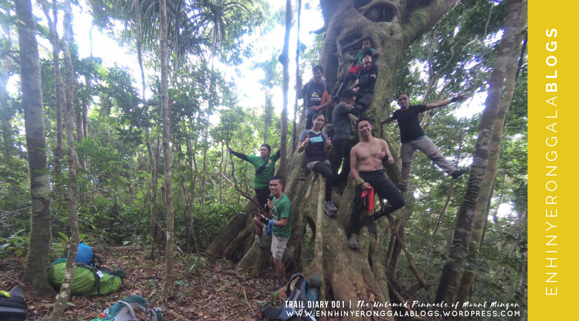 Balete tree. Photo-ops with the legendary mountain guide Kuya Junior and son Bilak.
After minutes of catching some breath and replenishing energy, we then proceeded and walk past 20 minutes to Station 3 and another 40 minutes to Station 4 before regrouping. The gradually inclined trail mainly composed of towering Dipterocarps towards Station 5 lasted for an hour. This station has a wide flat surface with a water source nearby about 10 minutes away making it suitable as a camping ground. Its already past 11 o’clock, after over 1000 meters of elevation gain, we decided to take our lunch and took an hour of much-deserved rest.
 Station 5 camp (~1200masl). The team having a lunch and a well-deserved rest.
At around thirty minutes passed 12:00nn, we resumed the trek towards Station 6, our target campsite for Day 1. We passed through a ridge where the vegetation starts to change from montane to mossy forest at a gradual assault. Mossy regions are favorite dwelling place of blood-thirst leech ‘limatik’. And according to our guide the area got really infested with blood-suckers during rains. Luckily no one in the team, got ‘limatik’ bites on the first day and second day, thanks to a good and favorable weather.
 Forest Canopies. This vast pristine greenery is home of the protected Philippine Eagle.
 Upper montane. Rodel, Ram, Macky and Kuya Junior go past a ridge with notable vegetation change, from here, trees with mossy trunks and branches grow only a few meters.
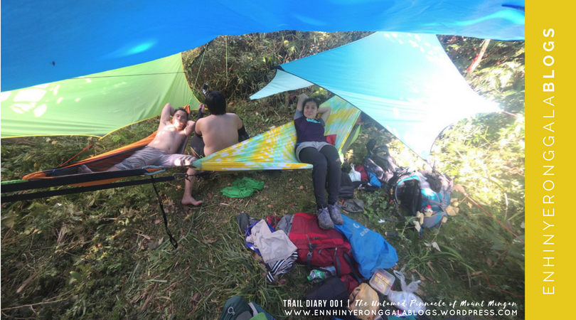
After 2 hours of hiking, we reached our target campsite Station 6 (1450+masl) quite early as expected. The level ground is not wide enough compared to Station 5 but it can accommodate about 3-5 tents and thick bushes covered the area. The limited camping ground is the reason why we all bring hammock instead of tent, as advised by previous explorers. Bivouac camping is more flexible to any terrain since the next camp will depend on where trailblazing will conclude for the next days. This will also minimize damages to thriving vegetation in the camp.
 Home away from home. Waterproof tarps covered our hammock camp, the green shrubs could have been cleared if we have a tent set-up.
After setting up our camp, since its to early to cook dinner, I roamed around and find some good viewing spot. Being a monkeyneer, I braved climbing and balancing through huge Pandan branches to have a glimpse of what’s ahead of us. All I saw was endless green ridges and peaks. A long and winding journey we have to battle. Parang walang katapusan, tulad ng mga pangako niya. Char!
 Overlooking. Yours truly with the view of Peak 1 (~1500+ masl) stands prominent in the background with Salakot Peak (1750+masl) peeking next to the right and the true Mount Mingan summit (~1900+masl) at the rightmost.
 Behind the Scene. Ram smiling before a camera, pangiti-ngiti pero kinakabahan yan mag-ala Spiderman ba naman makarating lang sa tuktok ng Pandan.
 Meanwhile. The hammock set-up and the chill campers. Ayaw nilang mahirapan umakyat dun sa puno ng Pandan kaya nagpahinga nalang.
 Spice girl. Eds cut garlic grains in preparation of our cooking sesh.
After taking few snaps, I went back to our camp and prepared our dinner. We prepared misua soup with patola and ground pork enough to fed our hungry stomach. A short socials came afterwards, laid our plans and itinerary for the next day. An ardous Day One made everyone fall asleep quickly. Lights off.
DAY 02 | 29 April 2017. The Road to Struggle

At 4 o’clock in the morning, the sound of an alarm and the cold embrace of the morning breeze, made everyone woke up. The team cooked the breakfast and lunch. After we ate breakfast and broke camp, the lead pack (Rullet, Eds and me) started the trek at 06:30am.
The trail is gradual passing through a ridge full of fully erect Pandanus and thick stand of Freycinetia until nearing the foot of Peak 1. From the foot, we maneuver through a quite steep ridge and a one-man trail which needs upper-body scrambling on vines and bushes. Just be careful not to grab the thorny trunks of wild berries (sapinit) and that notorious rattan vines (teka-teka) lots of them that ripped-off my backpack’s raincover. Uggh! T’was a heart-breaking moment, if I have known in advanced that the trail could be this unapologetic I should have used my old raincover.
 Teka-teka. Eds go past successfully this thorny rattan vines that looks like natural barbed wires, this was the once responsible of my torn raincover. Lakas ng kapit!

Unwelcoming vegetation. Me bowing before the notorious Sapinit (wild berry) and Teka-Teka vines… mahirap kapag matangkad at naka-long pack ka, sa sobrang respeto ko sa kanila lumuhod at gumapang nako.
After 30 minutes from Station 6, we reached a small flat ground that’s good for two person I think, an exposed area which serves as the viewdeck. A relief from last day’s hike in thick jungle under huge tree canopies. A promising panoramic view of green canvass of mountains, long-stretched coastline facing the mighty Pacific Ocean and the vast plains shared between towns of Aurora and Nueva Ecija can be seen. After taking some snaps, we advanced our way to Peak 1.
 Viewdeck. Eds on-the-roll with coastline of Dingalan (Aurora) and vast plains of Gabaldon (Nueva Ecija) in the background partly covered with morning clouds.
 Photobombing. Who photo bombed better? Sila papunta palang, itsura ko pabalik na. Kbye!
 Groufie. With the mid team -JC, Ram and Rodel posed for a group picture. Yung likod diyan kami nanggaling kahapon.
 Flora. Slender pitcher plants thrived on tree branches.
 Flora. Correa plant in a tropical rainforest.
Twenty (20) minutes of continued ascent we reached Peak 1 (1600+masl), with its surroundings totally obstructed by giant mossy Pandanus and a huge pine tree. From Peak 1, the trail is quite manageable with relatively flat to gradual ascent descent. Past 30 minutes, we passed ‘Durungawan’ a good spot overlooking the town of Gabaldon where an alternative straightforward trail can also be accessed. Similar explorations were also made using the Gabaldon trail.
 Mossy Pandanus. Long-legged Pandanus covered with moss obstructed the vicinity of Peak 1.
 Pine Tree. Yes there are huge pines thriving in Mount Mingan for years, the bowing branches showed struggles against extreme weather condition.
 Stolen shot. Rullet looked sideviews before a cleared viewpoint.
 Bilak. Our lodi and werpa lead guide, His father Kuya Junior took the sweep. Malakas tong batang to, iniiwan kami!
It took as an hour to reach Station 7, marked with a giant mossy pine tree with level ground space suitable for 3-5 tents we waited for regrouped. According to Kuya Junior, this is the last camp of the last explorers who eventually abort the summit mission after having caught in bad weather but they were able to advanced as far as Salakot Peak.
 Station 7. The leads Rullet, Eds and Yours truly at Station 7.
 Durungawan. A window-like viewpoint along the trail.
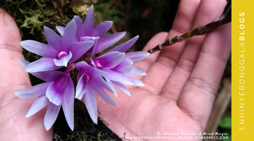 Orchid. A beautiful purple orchid sits before a mossy tree branch.
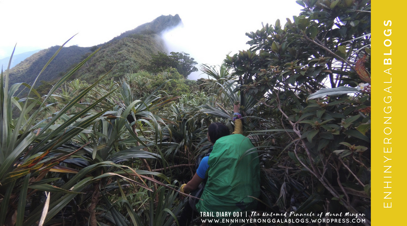
Past Station 7 the trail got really tough, appeared to be unused for months, we find ourselves carefully maneuvering through thick, slippery stands of overgrown Freycinetia and managed ourselves crawling under thick tunnels of shrubs and vines with our heavy backpacks on. Not to mention the ever strong grip of Teka-Teka that sticks and stripped-off my backpack’s raincover from time to time. Along the way, a wrong step got me outbalanced and had my right foot trapped in between floating Freycinetia stands causing abrasions on my calves and thigh. My legs got numbed for a few minutes until blood came out and the pain started to intensify. Being impatient, I started to throw tantrums. Tang-*na this! Hindi makatao yung trail.
 Road to struggle. Sprawling tangles of Freycinetia (Pandan) hurdled the trail that made us carefully balancing through it. Hindi makatao yung trail bes! Pang baboy-ramo. Acrobatic skills is a must.
 Groufie. Bago dumugin ang masusukal na Pandan. Umay level 999+
After an hour from Station 7, we reached the foot of Peak 2 Salakot Peak (referred as the False Summit, 1740+masl) often mistaken by previous attempt as the summit. With its prominence clearly visible from down below, it’s no wonder this was once mistakenly called the summit until available GPS data and past exploration accounts proved otherwise. Since its already past 11 o’clock, we decided to look for a flat ground to wait for regroup and have our lunch. From afar, I can hear Kuya Junior shouting and telling us to backtrack since there’s no more available established camping ground past Salakot Peak. We just stayed put and waited for them to reach our position.
 The False Summit. Eds pointing the ever prominent Salakot Peak, no doubt it has been once called the Mount Mingan summit.
 The False Summit. Yours truly in all smiles near the foothold of Salakot Peak.
Kuya Junior arrived with the rest of the team, he told us to backtrack to last level ground about 15 minutes away from our latest position. We took our lunch, and since it’s still past 11:00am, everyone agreed to assault the Salakot Peak and conduct a reconnaissance on the trail established by the last known explorers. And if there’s still time we can commence the trailblazing to advance the summit trail. We left our backpacks, we just bring assault packs with trail food and water. The trail leading to Salakot Peak is quite a technical ascent with portions of almost 90 degrees with very limited grip.
 4×4. Macky and Kuya Junior scrambling on bushes to advance to the top of Salakot Rock.
After 20 minutes, we reached the famed Salakot Rock, a huge Salakot-shaped rock with its pointed edge facing towards a sharp cliff. Some part of the rock surface are covered with lawn grass. Unfortunately the Eastern face was clad with thick fogs, in contrast to the Western Face which has a good clearing, this created a marvelous divide looks like a knife edge. From afar, another imposing peak about 200-meters higher than Salakot comes into view, that must be the true summit of the mountain range.
 Fear of heights. Rodel content sitting on a small flat area at Salakot Rock with background of thick fogs covering the left side of the ridge where we came from.
 Salakot Rock. A mammoth salakot-shaped rock formation with its pointed edge directed towards a cliff.
 Ridges. Macky reminiscing the struggle he has surpassed for the second day.
 Groufie on-top. The group on the top of Salakot Rock, do not be confused with Salakot Peak which is just right next to this mammoth rock formation.
From my position it appeared to be a different mountain, and for us to enable to reach its foothold, a long ridge of untouched jungle mostly composed of Freycinetia (pandan) has to be traversed about an estimated 4 to 5 kilometers long. I was disheartened with the fact that we only have a day to finish it’s way up and a day going down to jump-off, for me that’s far from impossible. But we took the chances at hand, after we marveled with the view and took photos and we didn’t waste any single seconds we have for that day and began re-establishing an overgrown trail of the past explorers. Ajah! Ginusto natin to diba?
 Moving on. The group started descent Salakot Rock towards Peak 3 (1720+masl) while Bilak and Eds were at Peak 2 (Salakot Peak, 1740+masl) an elevated portion of rock nearby.
 Salakot Peak. Bilak stood proud first at Peak 2 (1740+masl) seen from Salakot Rock.
 Descent. JC, Ram and Rodel maneuvering the edge of the rock descend towards Peak 3.
We made a 10-minute sharp descent and gradual ascent, we reached Peak 3 (1720+masl) covered with bonsai trees at about waist high. We followed a steep north trending ridge, which has still visible trail signs, until we reached a point that we are unable to see any established trail anymore and began making our own. We are having a difficulty in cutting and penetrating through thick and overgrown Freycinetia stands tangled with climbing bamboo. The blows of bolo towards this formidable stands could exhaust anyone trying to clear the area. From here it is already clear and evident, how arduous and difficult the next two days of this journey could possibly get but still everyone was in high spirits. At about 2 pm, after two (2) hours from Salakot Peak, we only managed to reach a small flat portion, we marked Station 9 and decided to stop there.
 Portal to the unknown. Past Peak 3 we go past this eerie part where lifeless trees stands still. Feels like a white-lady will appear anytime.
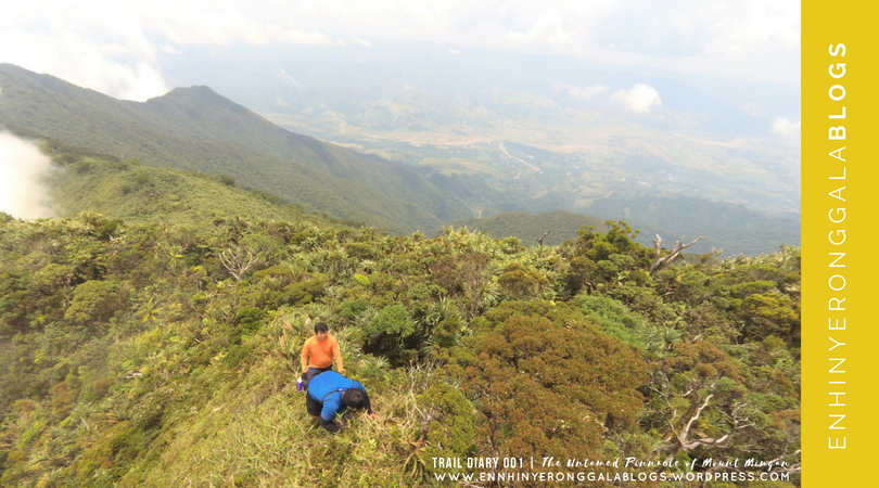
 Balancing. Acrobatic skills re-mastered on top of overgrown Freycinetia stands.
 Station 9. Our last stop for Day 2, a small flat portion a suitable campsite.
From Station 9, the GPS data showed we are only 3+KMs away to the true summit. We took a rest, eat some trail foods and chitchats. Kuya Junior seems hesitant if we can advance to the summit knowing the length and the difficulty of the trail blazing to be done. He said, “Kung hanggang saan lang tayo abutin bukas” -those exact six words struck right to my core. Though I don’t want to entertain the idea of failure, it implied that we will fall to the same fate as the previous explorers. I can see frustrations in everyone’s faces, who have the strong-willed mindset of reaching the coveted summit. Though disappointed, I tried to comfort and uplift everyone’s spirits “Kaya natin to Kuya. Tiwala lang, walang susuko nandito narin naman tayo”. Sad it may seem, with a very squeezed timeline and a long ardous task ahead, we were doomed to fail to advance to the summit. We traced our way back to our camp with clear enormous disappointment in everybody’s faces.
 Peak 3. View of Peak 3 as we went back to our camp.
 Mystery unsolved. We go past this barren portion again for the second time. Eerie!
 Bare. This bare tree exposed itself against the forces of nature.
But the hope brightens as soon as we met Team JJ, two experienced mountaineers Jon-jon Garcia of NEBMCI and Jaycee Aratan of Talahib with their guide, Kuya Carding at the foothold of Salakot Peak the same exact position where we left our backpacks. They just commenced their hike that day at 05:00am from the jump off and done this far. Werpa lodi talaga. This somehow alleviates my worries, our two guides can work hand-in-hand to fast track the trail blazing. They say that they will just spend the night in the flat area at the foothold of Salakot Peak and they will go with us the next day to assault the summit. In high spirits, we grabbed our backpacks and resumed our way back to Station 8, our second day camp.
 Let there be light. The rays of the sun passes through small openings in the forest canopy showed a good sign.
Past 04:00pm, we reached our camp. Set up our hammocks and started to prepare for dinner. We cooked dinner and had meeting for our plan for the next day. Weather permitting, majority decided to pursue the summit assault however one of our colleague, Macky decided not to continue and descend earlier to jump off with Byluck. We decided to just bring assault pack with us trail foods, emergency foods and water. We also agreed to abort the climb by 03:00pm (make it or break it), so we can go back to camp and descend early on Day 4. We cooked dinner and seems everyone got really tired everyone fell asleep as early as 07:00pm.
DAY 3 | 30 April 2018. The Biggest Decision

The trek commenced at 06:30 am. We reached Station 9, our last stop of the second day around 8:00am. Our guides resumed trailblazing. Most of the time, we have limited view of the surroundings because it is mostly covered with Pandan making the trailblazing even more difficult.
 The living legend. Eds pointing our lodi guides and trail blazers Kuya Junior and Kuya Carding, where we commence another rigorous day of trailblazing.
Just like what we did on the second day, sometimes we crawl underneath and most of the time we go over it balancing through its huge trunks seems were on a floating trail. “Pandaaan.. pandaaan layuan mo kami. Umay na kami sayo!” seemed a constant chant.
 Limatik. Due to rainshowers, this bloodsuckers are on the moves and I fell victim. Nagripohan realquick!
Everyone were still in high spirits. Jaycee and Jon-jon in the tail were also busy documenting every landmark and floras we encountered along the trail. Keep traversing the unknown, with no assurance if we can reach our destination on-time. Lunchtime, yet we are still on the ridge and can’t still sight of the last peak assault to summit because of the fog. We decided stop and eat our lunch.
 Break. To have lunch and to rest for a while. Pagod na kakatabas!
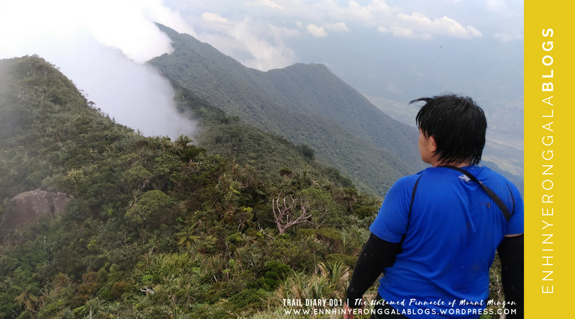
Base on GPS data, we were 1.5 kilometers away at an elevation about 1800+masl. After lunch, we resumed making our way through and until we reached Peak 4 (1750+masl) by 01:00pm. From here, we saw the last ridge we have to negotiate to reach the true summit. The excitement struck everyone when we saw the true summit appeared from a curtain of thick fogs. We have to negotiate a steep descent to the foot of last peak which is about (1700+masl). But we are slow moving because of thick overgrown Pandan that relentlessly hindered the trail.
 True Summit. The pinnacle of Mount Mingan slowly peeking from the clouds, in order to reach it we have to negotiate a steep descent towards its foothold and then ascend.
Past 3 o’clock, we only managed to reach a semi flat area where we huddled together. We are about halfway to the summit at an elevation of 1800+masl. We gathered together and faced with a difficult decision: to pursue or call it quits. We find it heartbreaking to quit because we are almost there and we can see it already maybe about an hour to the peak. It would also be more dangerous for a night trek back to camp because of the Freycinetia stands. We talked openly, we have emergency foods but we lack water. But everyone are positive about spending another night, we share the same sentiment to sacrifice a night. Upon agreement, we set-up our emergency camp. We settled for a small level ground and collected for dead leaves to serve as our ground cover. We we’re like sardines-packed in this ground to combat the cold. Our guide, Kuya Junior and Carding lit a bonfire to give us warmth in that cold night. Tiis-tiis lang muna!
 True Summit. Jon-jon (NEMBCI) pointing the long coveted pinnacle of Mount Mingan from our emergency camp.
 Survival camp. This was how our e-camp looked like.
 Happy faces. Jam-packed we fit ourselves in this small flat ground to combat the cold night.
 Looking back. Salakot Peak and the 3-KM long Pandan Ridge viewed from our e-camp.
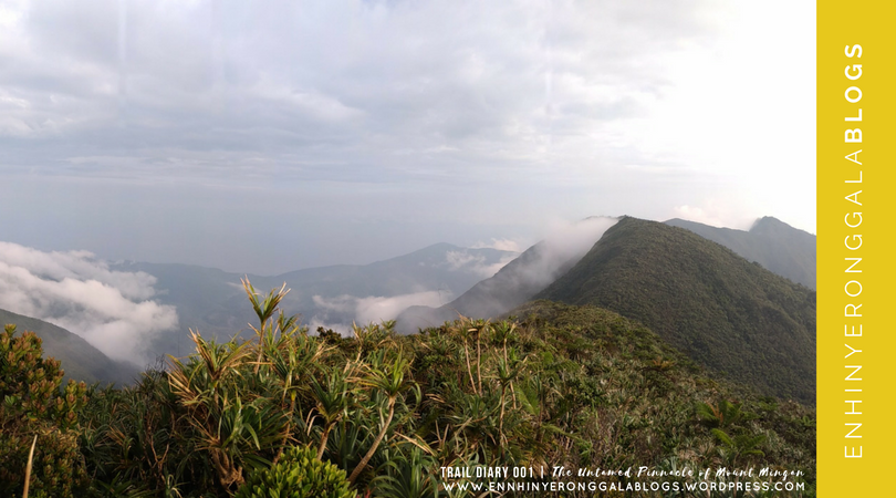
 Sea of Clouds. The unexpected afternoon SOC somehow relieved everyone.
We’re still lucky that it didn’t rain that night. The Lord has been merciful that day, He didn’t allow any single drop of rain because if it did we might end up soaking cold and this blog might have a different story. The sky was so beautiful, there are plenty of stars. Some got a good sleep (evident by loud snores) while I am not comfortable with my position and its very cold. Wide awake, I patiently waited for the sunrise.
https://cdn.ampproject.org/v0/amp-auto-ads-0.1.js
DAY 4 | 01 May 2017. The Long Awaited Summit Day

At 5 o’clock in the morning, the sky lit colors of a beautiful morning, seems a very promising day indeed to everyone. All were in high spirits for the Summit Day, the first of its kind in Mount Mingan.
 New day. A one night stand against forces of nature in the middle of the mountains.
From a usual hot meal and coffee, we fit ourselves shared energy bars and trail foods to fill our hungry stomach that day. We continued our ascent to summit with excitement, still overgrown Freycinetia stands and Pandanus dominated the trail. Our guide cut some small climbing bamboo chutes with water inside that serves as our water source. It tastes good, almost similar to coconut water. Along the trail, we noticed some pretty unusual coral-like flora, the coral plant, which can only be found in Mount Mingan.
 Talk about survival. Rullet sipping water from a chute of a climbing bamboo.
 Coral plant. A rare parasitic and critically endangered flora that can only be found here in Mount Mingan.
After an hour, we reached the summit of Mt. Mingan. It was indeed an exhilarating moment. Traces of wild boars can be found in the area. There’s not much view on the summit ground because it is obstructed by huge pine trees and Pandan scattered all over the place. You need to climb the trees to get a panoramic view.
 From the top. Views of nearby mountains of Nueva Ecjia, Mt. Labi and Mt. Kemalugong.
 GPS. As we explored the entire summit vicinity, our GPS located and recorded a maximum 1909+masl elevation which the group marked as summit.
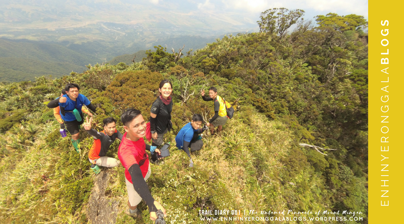
 The Pinnacle. Pride itself to be the first group to explore and reached the summit of Mount Mingan.
 The Chosen (Ang Itinakda). Pride itself to be the first group to explore and reached the summit of Mount Mingan, Tipidkadas with Team JJ of NEBMCI and Talahib Mountaineers.
 Strava record. The newly established and documented Mount Mingan summit trail.
After an hour, we descended back to camp, fast pace. Took a long-deprived meal of biscuits (no time to cook) at Station 8 and resumed our trek back to jump off. It was me, Eds and Rullet on the leadpack, our guide Kuya Junior took the sweep. It’s already pitched black when we go past the Balete Tree landmark. With too much exhaustion, we managed to reach Lipos River around 6:00pm but hardly traced the exit trail towards Kuya Junior house. I felt too exhausted already maybe because of lack of sleep and hunger. Eds called Macky thru phone to fetch us at the riverside because we hardly lost sight of the trail and I’m feeling weak. We reached the house of Kuya Junior at 7:00pm safe and sound. Thirty minutes after, Kuya Junior with the mid pack arrived. We feast on chicken tinola and buko juice, our celebratory meal for this successful expedition. Truly, it was indeed a very challenging and memorable exploration climb we had and foremost we are more than thankful to God for His guidance. Ciao!
Mount Mingan taught and showed me that the road to the true pinnacle of success is never easy. But if you have the courage and determination to go past every tests and obstacles thrown before you, no doubt, you will surely make it to the top. LABAN LANG!
See you again on my next trail diary.
Love,
enhinyeronggala

PS. I personally dedicate and would like to give credit to everyone who had been part of all the previous explorations to advanced the Mount Mingan summit trail. We would have never reached the top without your dedication and effort. Lest, we only continued and finished what you started. It will always be a collective effort and you all did a great job. Our success in reaching the untamed summit of Mount Mingan is also your success because you all played a big part on this. Thank you!
15.480833
121.405000


 A SAMPLE SHOT I MADE IN KAPARKAN SPRING TERRACES.
 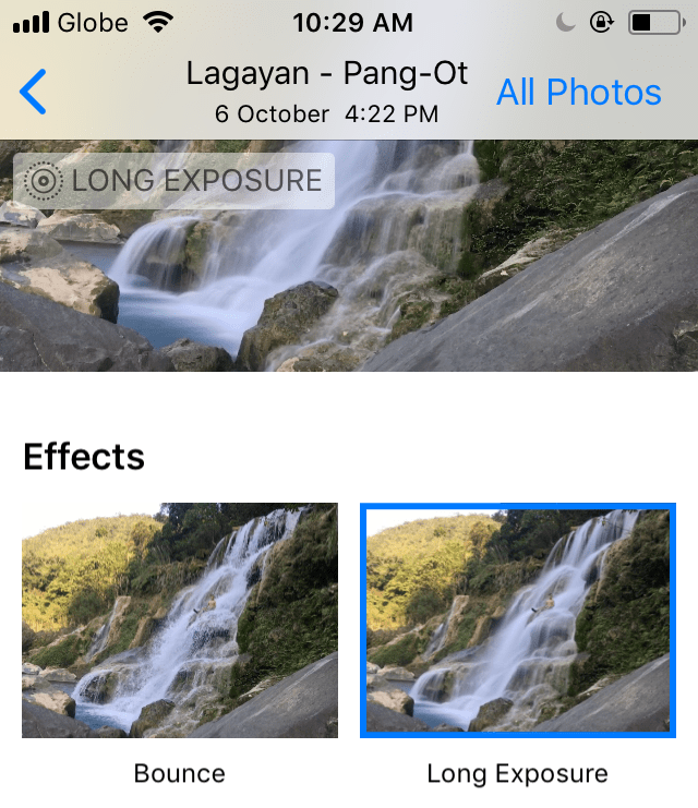 SWIPE UP TO SEE THE FOUR OPTIONS INCLUDING LONG EXPOSURE
 The interface after I tap the Long Exposure option.
 So this how it looks like after I edited it and saved on my Gallery.


